


The Wood Ridge Farm Brewery
IMPORTANT: Please call Barry Wood before coming out.
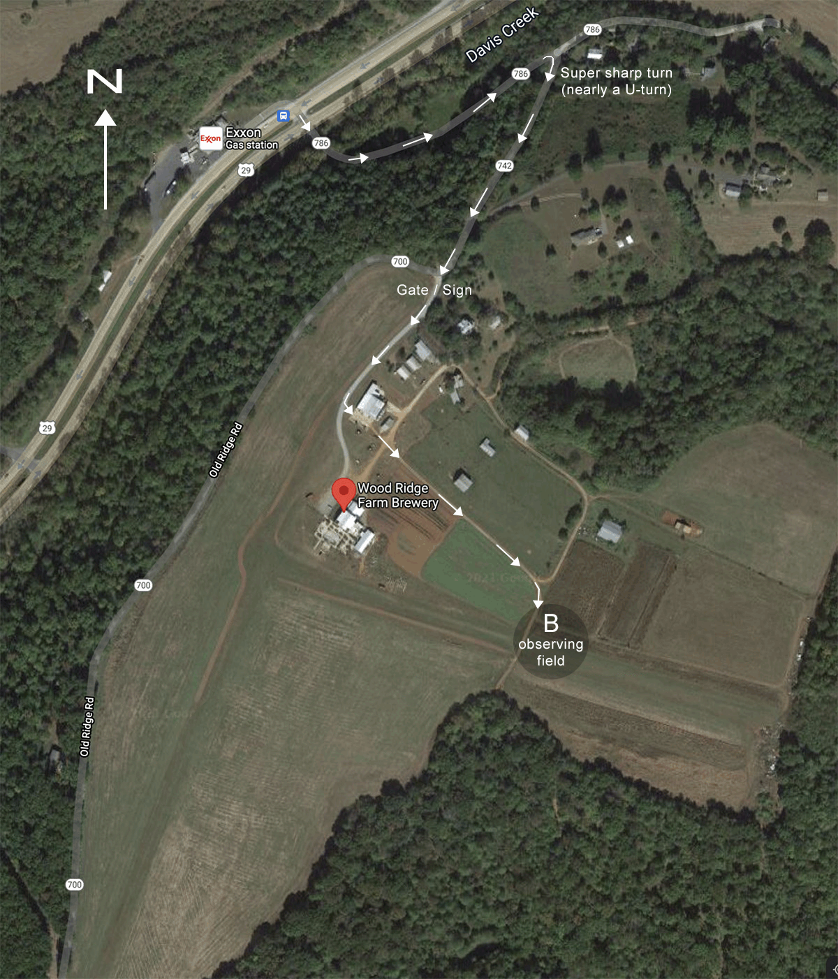
The brewery is located at 165 Old Ridge Road, North of Lovingston. From Charlottesville, proceed South
on U.S. 29 for about 25 miles (from the intersection with I-64). After passing into Nelson County, you’ll
go over two more hills, then pass a Wayside on your left. You’ll be on a level section of highway, curving
gently to the left, with turnoffs to Rt. 6 on the right. Notice an Exxon station coming up on the right.
Take the last LEFT (across the median) before you get to the Exxon. There are pennants advertising
beer/brewery on the northbound side of Rt. 29, at the road where you turn left.
After about 1000 ft. travel on this small road you’ll come upon an EXTREMELY SHARP RIGHT TURN. After
you’ve rounded the bend, continue a similar distance and straight ahead you’ll see the gate to the
brewery property, with a sign above and across the driveway “WOODRIDGE FARM BREWERY.” The road
curves to the right at this point, but you will go straight ahead, onto the brewery property.
This year we are observing only to the East of the Brewery, towards (or sometimes even beyond) “field
B” on the map. Use of field A has been deprecated (and no longer shows on the detail map). If your
session is one for outreach coordinated with the brewery, we set up immediately to the East of the
brewery, in a line that is between the brewery and field B. Astronomers would set up about twenty to
thirty feet apart along that line. On the map, the letters in the word “OUTREACH” show approximate
positions of where individual astronomers would set up.
Ideally we would have eVscope and other electronic scope users set up closer, and those with larger,
purely visual scopes set up farther from the brewery. This way, as visitors first come out towards the
astronomers, they will first observe screen images that are easily seen with eyes that are not yet dark
adapted. Those visitors that have a continued and deeper interest can then proceed along the line,
going ever further into the darkness. As they do so, their eyes become dark adapted to better
appreciate the visual views in the telescopes further to the East.
If the session is not for outreach, or you are just coming out as an individual seeking dark skies, then you
can set up in “Observing field B” as shown on the map.
Directions: After climbing up the brewery driveway and some buildings on the left, turn left at the first
opportunity, which takes you around and past the last building on the left. You’ll be heading East,
towards and then past a wide field. Continue on this road towards the East, then as it bears right (to the
South), you will travel another 100ft. and be in the observing area B. When doing an outreach session,
from here turn back towards the brewery, driving onto the grass directly towards the brewery, and
when you park at your observing position, please face your car North. Near to the brewery, the
electronic scope operators should set up behind your car, so you can bee seen from the brewery. But if
you’re setting up further East, for dark sky visual observations, you might consider setting up to the East
side of your vehicle, as the taproom produces a fair bit of glare, and your vehicle might provide some
shade from that glare. However, then you are less visible to visitors that are heading down the line. It’s
up to you.
Note: If you see RV’s parked closer in to the Brewery, please keep quiet.
Lagniappe Farm – Somerset 2 miles southwest of James Madison Montpelier Estate
(Private)
9389 Constitution Highway, Somerset, VA 22972 -Call Mark Ownby or Merian Burkett at 540-661-3537 for availability.
Somerset 2 miles southwest of James Madison Montpelier Estate. Location is 1/2 mile east of the Somerset Center Store on Route 20 (Constitution Highway)
Morning Calm Observatory (Private):
Heading North on Rt 29; turn left on Hoover Road (Rt 609); turn right (2.1 miles) on Rt 607 (Ridgeview Road); turn left on Woods Ridge Lane (first house on the left).
30″ Obsession at Morning Calm Observatory
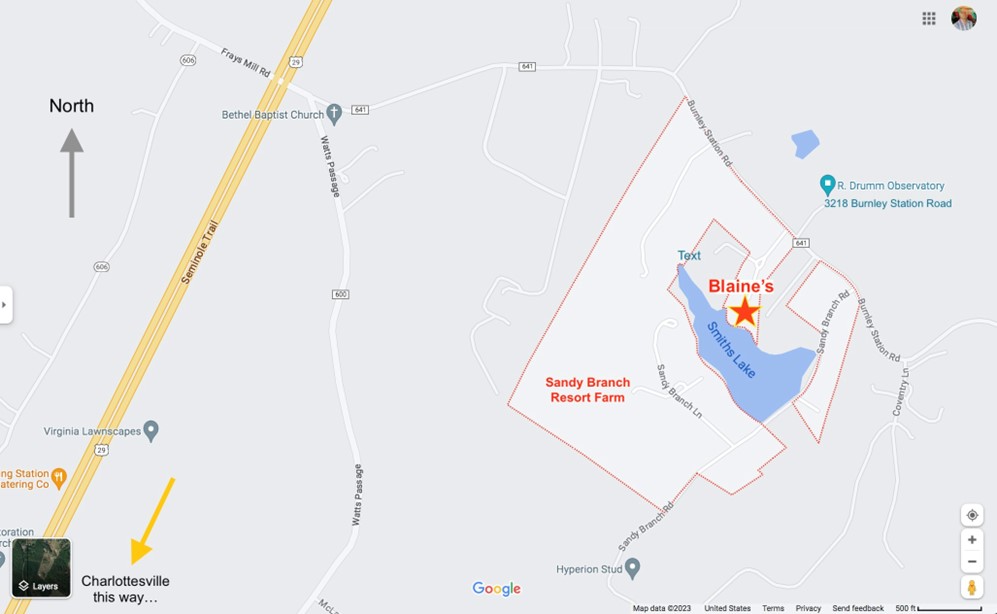
Sandy Branch Vineyard (Private):
Blaine Korcel’s property resides in Sandy Branch Resort Farm (google that for a map or directions) at 3201 Burnley Station Rd. in Barboursville, VA.
Directions: from Charlottesville go North on Rt. 29. A few miles North of Proffit/Airport Rd, turn right at the traffic light for Burnley Station Road. About a mile down the road you come to Sandy Branch Vineyard on the right. Immediately after a 25 MPH speed limit sign is Blaine’s driveway on the right – for clarity, see the map for Sandy Branch Resort Farm below. When going down the driveway, bear left at the fork. Blaine’s property allows observing from the carpark area right by his house (if you don’t mind a few lights nearby), or from a little further north in the field, to the East along the driveway. You need to contact him for permission and to arrange the session. <blaine.korcel@gmail.com>
Dogwood Ridge Observatory (Private):
401 Forest Ridge Drive. Near Kidds Store between Scottsville and Palmyra. Phone 434-286-2320.
From Charlottesville take Route 20 South to Route 53 toward Monticello.
Left on Route 53 East, 3.2 miles to Route 795.
Right on Route 795 South, 2.6 miles to Route 620.
Left on Route 620 South, 12.2 miles to Kidds Dairy Road (669).
Right on Kidds Dairy Road, 0.4 miles to Forest Ridge Drive.
Right on Forest Ridge Drive, 0.6 miles to 401 Forest Ridge Drive (on the left).
You must be logged in to post a comment.